Industrial Area
Kopparthy, Andhra Pradesh
11 km from Kadappa Airport
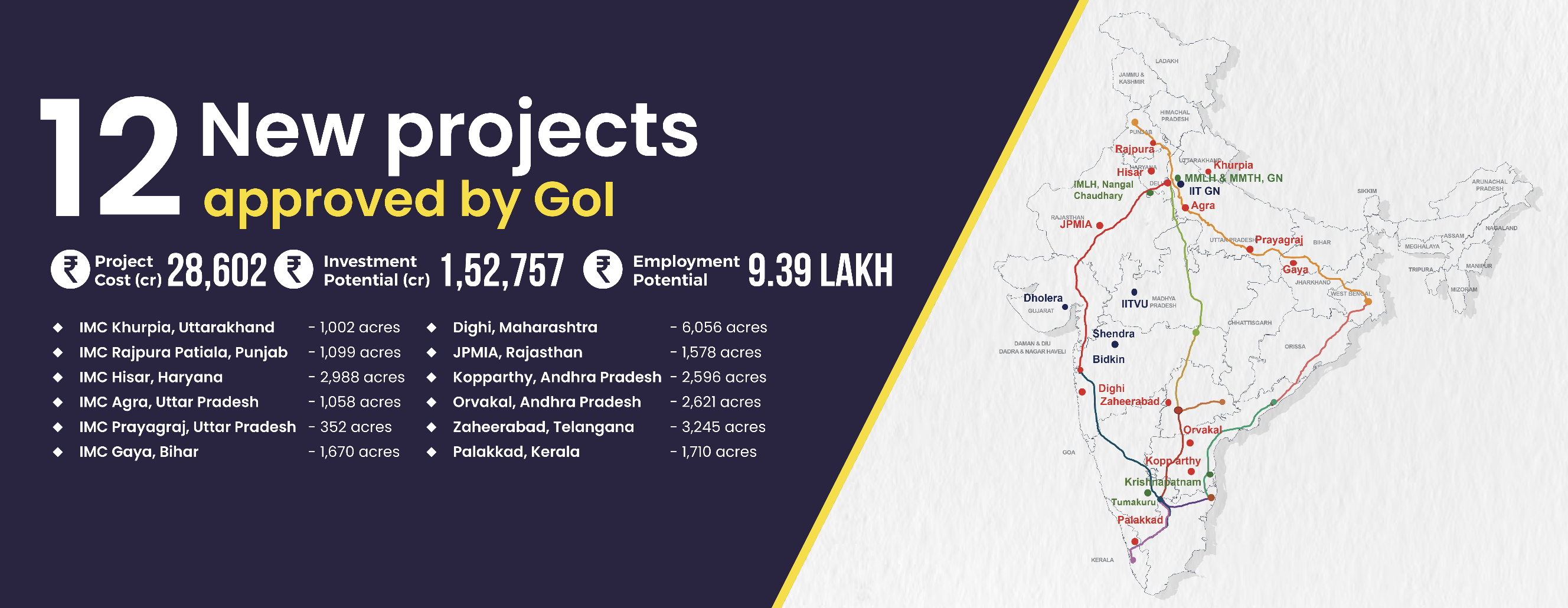
The Kopparthy Industrial Area, located in Kadapa District under the Vizag-Chennai Industrial Corridor (VCIC), spans 2,596 acres. Strategically connected by SH 51 and NH 40, it is 13 km from Kadapa Airport. With an investment potential of ₹8,860 crore and a project cost of ₹2,137 crore, the area aims to generate 54,500 jobs. AP Industrial Corridors Infrastructure Development Corporation Ltd (APICDC), the SPV with 50% shareholding each of GoAP & GoI shall implement the project.
Project Overview
Project Area
2,596
acre
Project Cost
2,137
crore
Investment Potential
8,860
crore
Employment Potential
54,500
jobs
Key Benefits
Boost economic activity in Rayalseema
Within 250 km of Chennai and Bengaluru
Connectivity
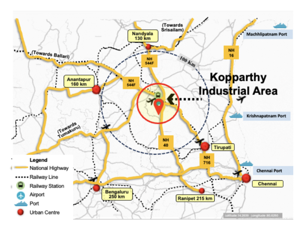
Transport Network
| Name | Distance |
|---|---|
| SH-51 (Kadapa - Pulivendula) | Adjacent |
| NH-40 (Kurnool - Ranipet) | 5 km |
| NH-716 (Kadapa - Chennai) | 8 km |
| NH 544F (Ananthapur-Vijayawada) | 8 km |
| Name | Distance |
|---|---|
| Krishnapuram | 9 km |
| Kadapa Junction | 13 km |
| Name | Distance |
|---|---|
| Kadapa Airport | 11 km |
| Tirupati International Airport | 150 km |
| Name | Distance |
|---|---|
| Krishnapatnam Port | 200 km |
| Chennai Port | 270 km |
| Name | Distance |
|---|---|
| Kopparthy Rail Cargo terminal (under development) | 9 km |
| Krishnapatnam | 196 km |
| Ananthapur MMLP | 157 km |
Land-use Plan
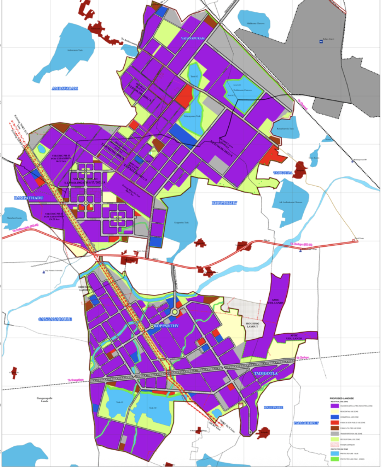
Area (acre) Distribution
| Land-use | Area | Area (%) |
|---|---|---|
| Industrial | 1213 | 47% |
| Commercial | 54 | 2% |
| Residential | 136 | 5% |
| Amenities (Public / Semi-public) | 27 | 1% |
| Parking | 129 | 5% |
| Roads | 337 | 13% |
| Utilities | 28 | 1% |
| Greens /Buffers/ Water Bodies | 671 | 26% |
| Total | 2595* | 100% |
Focus Sectors
Renewables
Auto components
Metallic minerals
Non-Metallic minerals
Textiles
Chemicals
Engineering goods